
Roadtrip to Northern NSW: Hiking Trails Along the Way

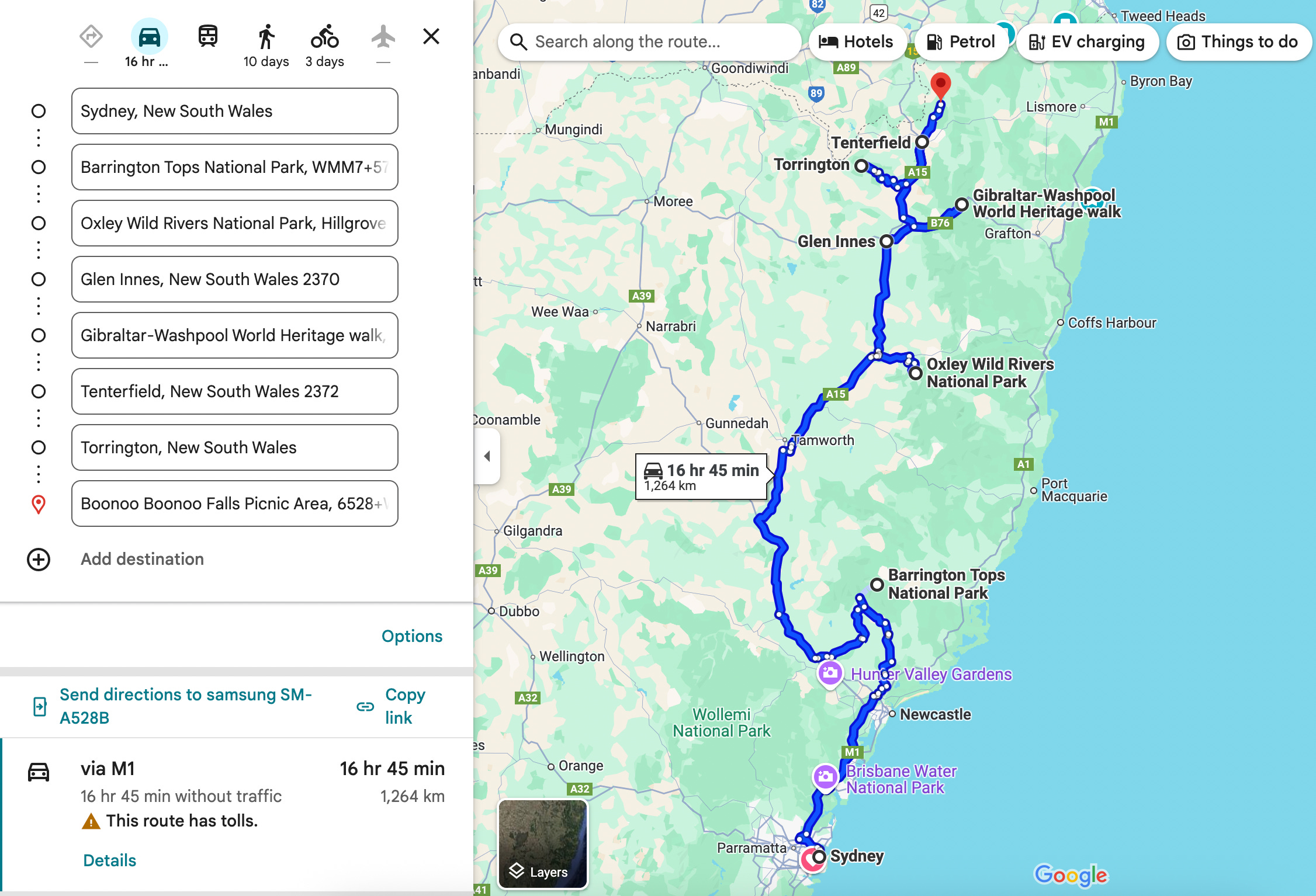
Let’s build a 2-week long road trip itinerary to Northern NSW, departing from Sydney, based on our hiking experiences.
Barrington Tops National Park
Drive through the Barrington Tops National Park was magical — rich, green, dense, deep, and mystic. Some of the scenery belonged to a fantasy land and inspired me to write lots of poetry at the time. It’s incredible that such a beautiful place is only 3.5 hours drive from Sydney.
I wish we had spent more time here. Please stay here longer than what we did (which was about 2 days).
We stayed at the Gloucester River Campground. It was quite a large campground with toilets and BBQ facilities for cooking -- a popular choice for families.
Gloucester River Walking Track: this 2.5km loop began from our campsite — of course, we had to take a wonder. Yes, there is a river crossing, but it’s not difficult (just don’t attempt it during heavy rain). We got our feet wet a little and it was freezing, but fun. It’s a short, peaceful and scenic forest walk — took us 45 minutes (we snacked and took our time).
Apparently, you can swim in the river, and I remember seeing teenagers dip the bottom halves of their bodies. During April, it was painfully cold, so unless you desire icy baths, it may be best to bathe during summer. We also saw long-necked tortoises, which were so cute.
Lovely trail and campsite for families. For more info, check out - https://www.nationalparks.nsw.gov.au/things-to-do/walking-tracks/gloucester-river-walking-track
Sharpes Creek Walking Track: this is the bigger (4.5km) loop next to the Gloucester River walking track. Took us 1 hour 30 minutes. Why not?
We got to walk through an enchanted rainforest with green trees dressed in moss and ferns. There were 3 minor crossings of Sharpes Creek, which eventually connects back up to the Gloucester River. There was a water dragon lazing on a big wet rock along the shallow end of the creek. Bring a camera along; there is a lot of magic to capture on this hike.
Note: we didn’t mind the steep climb back on the road (and then walking back along the road), but most people return through the forest. Your choice.
For more info, check out - https://www.nationalparks.nsw.gov.au/things-to-do/walking-tracks/sharpes-creek-walking-track
Gloucester Tops Circuit: not far from our campground was this gorgeous 8km hike that connected Gloucester Falls Loop and the Antarctic Beech Forest Loop, as part of a larger loop. Essentially, we did 3 hikes in one go (2 hours and 45 minutes).
We don’t often see rainforests with old and wide trees that reach to the sky in Australia. I let out a few “wow”s on this journey and felt grateful. If you’re in the area, this is a must-do trail. Bring a camera along too.
The trail is narrow, slightly up and down, but not difficult. It’s well-marked with wooden signs that show ‘short walk’ and ‘long walk’. We made sure to check out every side trail on our way. It’s also relatively popular, so you’ll come across a few other people on the trail.
Expect to walk over rich brown soil, stones, rocks, wooden boards, a few small tree roots, and a few stairs — it’s a mix. If you find fungus fascinating like I do, then there are plenty of those on the trail as well. Most of the trail follows the Gloucester River and there are many little easy crossings (maybe 5-6). There are plenty of lookouts and picnic areas along the way.


For more info, check out - https://www.nationalparks.nsw.gov.au/things-to-do/walking-tracks/gloucester-tops-circuit
It’s a shame that we didn’t take many pictures while exploring. We were fully immersed in our hikes.
Lol, we were clearly surprised to see a van and a non 4WD car in front of us. At the campsite, the drivers also revealed that they were unsure how they would return back home if the rain continued.
Oxley Wild Rivers National Park
World Heritage-listed Oxley Wild Rivers National Park has fantastic scenery. You will find green forests, lots of waterfalls, and a fierce wild river, as the name suggests. If you have a 4WD drive, this can be a very adventurous place to explore.
We were there in early April for 5 days. It was cold and stormy every night, so make sure you rug up. We came across 3 other couples at campsites.
We stayed at Dangars Gorge Campground. This is quite an accessible campground with great views. It had picnic tables and toilets. I loved seeing grey kangaroos in the early morning.
Dangar’s Falls Walking Track: 0.6km return, Grade 2. If you’re staying at the Dangars Gorge Campground, this is a short, well-maintained and cute trail that you should explore. Very nice views of the falls, so bring a camera along too. More info - https://www.nationalparks.nsw.gov.au/things-to-do/walking-tracks/dangars-falls-walking-track
McDirtys Walking Track: 6km return, Grade 3. This is a longer walk to view the Dangars Falls (took us about 1 hour 30 minutes). Lots of lookouts on metal platforms with a mystique due to the misty atmosphere. It was not the best for taking pictures, but rather unique. The track was well-maintained, relatively flat, and even had handrails in a section. I recommend exploring this route. https://www.nationalparks.nsw.gov.au/things-to-do/walking-tracks/mcdirtys-walking-track
We also stayed in Riverside Campground. This was an adventure! NSW National Parks will warn and say “only accessible with a low-range 4WD” — do not go down to this campground unless you trust your vehicle and its tyres. Dodge in bad weather. Otherwise, it was a very cool, bumpy and scenic drive down a steep, curvy and narrow dirt track (with a rocky base) down to the Apsley River. Don’t try to walk it; the steep, slippery and rocky (crumbly) base of the ground is exhausting (unless you want a trail to test your knees).
Down near the Apsley River is peaceful. That was a beautiful, crystal clear river that glowed under sunlight. Standing in between tall, grey and bare mountains, you feel so small in this world. Exploring the river on foot was fun too. The ground is uneven with lots of small rocks, so be careful. There are spots to swim, especially when the river flows calmly. Yes, that’s what we did in freezing weather; it felt like an ice bath.
The campground is quite big and spreads along the river, so there would be a lot of privacy and space, even if the campground was full. The only downside is that it was difficult to pitch a tent at this campground, due to the rocky surfaces.
At night, the sky looks magical. This is a place you want to get lost for a couple of days — a very remote campsite with no reception (and as mentioned, challenging access). It can be an inspiration for painters, poets, musicians, and photographers. We set the campfire and warmed our hearts with a pot of comfort food.


Budds Mare to Riverside Walking Track: I don’t think we actually completed this track. We made up a route by travelling along the river and then climbing steeply through the forest. Dense with eucalyptus trees, moss and fungus. We spotted a few bush turkeys too. We only spent 3 hours on this trail (instead of completing it) because we lost our map (no internet connection), the trail was challenging, and we wanted to drive the Jeep out of the campground before the rains came.
The last place we stayed was the Wollomombi Campground. It was cheeky of us to not book this campground. Here is our excuse; we got worried about the approaching rains (rising river water and dirt track being too slippery for the Jeep to crawl back up), and left our campground a day early. On our way, we met other explorers who recommended us to check out the Wollomombi Campground and the nearby trails. So we did.
This is a spacious campground with toilets and fire pits. There is a picnic area with an info board, tables and BBQ facilities nearby.
Wollomombi Falls: about 4km out and back, well-maintained, up and down track with 3 main lookouts. This trail crosses the Chandler River (which connects with Wollomombi Falls) and Wollomombi River multiple times, before looking out to the falls. Your journey will end at the Chandler Falls Lookout seeing the Chandler River once more.
The terrain is a mix of narrow dirt tracks and metal platforms leading up to the lookouts. Aussie bush and large mountains. While the trail isn’t picturesque, the views from the lookouts are (although it was a little hard for me to see through the mist again).


Here is some more info and the map for the trail - https://www.alltrails.com/trail/australia/new-south-wales/wollomombi-falls
Chandler Lookout: David did not come on this trail, as he was tired and decided that he’d seen enough of the Chandler River. At first, I was a little confused when I saw the sign for this trail, as I thought we had already seen the Chandler Lookout. Turns out, there are many ways to view the falls. This trail actually heads in the opposite direction and goes through 3 different lookouts.
It is a 3km out and back, narrow, zigzag track that goes through the edges of a forest, looking out to the mighty mountains. With lots of small rocks and a few fallen trees, this route required a bit of scrambling. It was also really windy and exposed. The first half of the journey was a 200m descent, then I had to climb back up to return to the campsite.
I thought the journey was tough (but not too tough) and a little more adventurous (maybe because I was alone), although this was 2 years ago.
Here is some more info and the map for the trail - https://www.alltrails.com/trail/australia/new-south-wales/chandler-lookout
I added some of the Jeep driving videos below. They are a little deceptive though, as I filmed during the calmest moments when I didn’t need to hold on.
Glen Innes
This is a large town in between the Guy Fawkes River National Park, Gibraltar Range and Washpool National Parks, Nymboida National Park, Mann River Nature Reserve, and Kings Plains National Park. There is plenty of nature to explore around here and Glen Innes is also known for its annual Celtic festival (1-3 May).
The Super Strawberry: a cute strawberry farm where you can purchase strawberry jam (and all of its varieties) and strawberry sauce, or snack on some scones/pavlova/sponge cake/ice cream with strawberries.
The Local: nice cafe with lots of food options. We shared either their pancakes or the french toast a few years ago and enjoyed it.
Sweetie Pie's Bake Shop: it’s won many awards over the past decade, so we had to try this place. They had a large variety of options with some fancy combinations of flavours. David liked these pies and gave them 8.5/10. I am not a fan of soft buttery crusts as they leave an oily feeling in my mouth afterwards (prefer crispy flakey crusts instead), so while the fillings were very delicious, I would give them 7.5/10.
Gibraltar Range and Washpool National Parks
This is a unique part of NSW that connects eucalypt forests, rainforests, waterfalls, wetlands and granite tors — home of the world heritage walk. It’s 45 minutes drive from Glen Innes and 7.5 hours drive from Sydney.
Gibraltar-Washpool World Heritage Walk: the 4-day, 46km loop is the best way of seeing the different landscapes of both national parks. If you have multi-day hiking experience, this is not a difficult trail at all. Highly recommend! It was really fun with swimming spots, waterfalls and lovely campgrounds. Check out the Overview and Walker’s Notes.
Little Dandahra Creek Walking Track: this is the side trail we explored while completing the Gibraltar-Washpool World Heritage Walk. This is a 13.4km return journey with almost 300m elevation gain. We completed this in about 3 hours and 45 minutes (returned under heavy rain). Access the map here - https://www.alltrails.com/trail/australia/new-south-wales/little-dandahra-creek-walking-track
You can park at the Platypus Picnic Area near the Gibraltar House (which you can rent out for comfy accommodation - https://www.nationalparks.nsw.gov.au/camping-and-accommodation/accommodation/gibraltar-house).
Most of the trail follows the beautiful Dandahra Creek and wildflowers. The terrain is relatively flat resembling a narrow and sandy fire trail. The trail has minor ups and downs and is easy to follow. In my previous post, I described this part of the journey as:
“This is a cute scenic walk that starts like a sandy dry fire trail but evolves into wetlands. We passed waterways and a big creek, which is apparently swimmable.”
This trail ends at the Mulligan’s Hut Campground. This is the biggest campsite in the national park and even has shower blocks. It’s popular with families (probably due to the swimming spots around).
On the way back, as it rained, the ground became mushy, muddy and soggy. It was much more fun to do this trail in sunny weather (as most trails are).


Tenterfield
We called this place the ‘Town of Thor’ (or the Town of Thunderstorms). It was windy all day long. Yes, we’ve only been here during winter, but the town is on a hill and the constant wind gave me a headache. Tenterfield is a cute town close to the Queensland border, Boonoo Boonoo National Park, Torrington State Conservation Area, Girraween National Park, Basket Swamp National Park, and Sundown National Park.
It’s got lots of shops, a gym, cafes (with a surprising amount of delicious gluten-free options) and an alternative health store. Some places that we checked out;
Little Nook & Co: if you have a sweet tooth, their treats are delicious. I had one of the best gluten-free treats ever there (highly recommend their caramel slice and gingerbread overnight oats). Their Buddha or health bowls are great, but I recommend asking the salad sauce to come on the side or taken off completely (otherwise they drown the salad in sauce).
The Courtyard Cafe: large, quiet and peaceful with power sockets (so very good to work from there), ok food (but they had a full menu of gluten-free options, so I was grateful), and burnt coffee.
Boonoo Boonoo National Park
About 30-minute drive from Tenterfield and very close to the Queensland border is this national park with trails that follow the Boonoo Boonoo River and falls. This place gets a lot of wind during winter, so rug up. If you’re exploring during summer, there are lovely swimming spots.
We saw some nice campgrounds here with firewood, picnic tables and toilets. However, there is snow in this area during winter, so make sure you have a suitable tent.
Boonoo Boonoo River Track: found on All Trails, this is a 13.4km return journey, which would take about 4 hours with a 15-minute picnic break and a few additional photo breaks. Access the map here - https://www.alltrails.com/trail/australia/new-south-wales/boonoo-boonoo-river-track
The hike starts from the Cypress Pine Campground. There are obvious trail markers and signs around to point you in the right direction. Follow them to the Platypus Hole Picnic Area, along the Boonoo Boonoo River. Most of the trail is on a slight downhill following this river, which makes it quite a pleasant journey.
There are a few split-offs to watch out for. The first one comes up within the first kilometre, splitting off to the right, which you can ignore by continuing straight. Immediately after, you’ll see the main road. Follow the bush trail that diverges off slightly to the left. The second main split-off is again to the right for the Mackays Walk, which the signs will show. Keep hiking ahead along the river.
Soon after, there are two small river crossings. Both look like rocky hills with streams of water flowing towards the river between the cracks, so very easy to cross. If there has been rain over the past few days, be careful of your foot placements, as some parts of the rocks are slippery with moss grown on them. This is a lovely spot to take pictures — green trees in the background, a deep flowing river and large rocks.
The terrain is relatively flat and goes through a green forest. David thought it was ok (and a bit interesting); I thought it was quite fun. Somewhere along this route, I remember seeing a large house on the other side of the river, built on a hill. It may be a non-camping accomodation option — looked pretty.


About 2km later, the famous Boonoo Boonoo Falls Lookout began to appear from the distance. First, you’ll see a bench to sit out with a skinny river flowing down as a waterfall. Keep going, as the trail will curve around and give you a much better view (and another bench to sit on). This is where we had our snack break, took pictures, and munched on some fruit and protein chips. The waterfall is much wider and taller, and bounces down over the rocks, feeding into the large river. It’s wild and worth admiring.
What makes this spot famous? The Australian bush poet and author, Banjo Paterson, proposed to his lover, Alice Walker, in front of this waterfall. He heard, “yes” and the spot became a romantic escape for other couples. Cute!
We retraced our steps back to the Jeep and realised that going uphill made the trail a little bit more challenging (we were no longer feeling so bouncy). But we carried out a long conversation and I lost myself dreaming away, so time quickly passed. If you are in the area, this is a nice trail to do.


Cockatoo Walk: found on All Trails, this is a 9.3km loop, which would approximately take about 2.5 hours to complete. Access the map here - https://www.alltrails.com/trail/australia/new-south-wales/cockatoo-walk
The trail starts from the Cypress Pine Campground. The first 2.5km is a constant uphill. There are obvious trail markers and signs around to point you at the right direction. Follow them along the river for the first 600m, then take a right to Casuarina Trail.
This is an easy fire trail that goes through a green forest. A few parts of the trail are ruined by fallen trees; just step over them (we weren't bothered). Here, we searched for a cockatoo with high hopes but did not see a single bird — a bit disappointing.
This fire trail joins a dirt road, and we took a right turn to continue our circuit. The dirt road goes on for almost 2km and it’s a bit boring. Eventually, you’ll see another right turn to Girder Trail back into the forest.
After about 1.5km, you’ll pass 2 river crossings. As mentioned before, both crossings are rocky hills with streams of water flowing towards the river between the cracks, so very easy to cross. Watch your foot placements, as some parts of the rocks are slippery with moss grown on them. Great spots to take landscape pictures and have a picnic.
About 300m later, the trail will join the Boonoo Boonoo Falls Road. At that point, you will know that you have travelled about 70% of the way. Take a left, then the first right. Soon, you will see Morgans Gully Picnic Area. The trail gets a bit windy afterwards and follows the river once again.
Eventually, the trail will join the Boonoo Boonoo Falls Road again for a short time, then split off left to the Cockatoo Walk, crossing the river. These river crossings have been the best parts of the trail. 500m later, we saw the Jeep again.
This wasn’t an exciting trail. But if you enjoy being in nature for a simple stroll and have the time, why not?


Torrington
This old mining town saw its peak popularity in the 1920s. It is home to the Torrington State Conservation Area and lots of Australian native animals.
Seriously, tall strong kangaroos were hanging out in the children’s playground when we were driving past. Goats were free doing their own thing. Quolls were hanging out near the info board. We saw more types of animals than humans in the village. It was quite cool.


Torrington State Conservation Area is a place to explore lots of short trails that lead you to unique views. Expect to see picturesque views (especially during sunrise and sunset), peaceful picnic areas, and granite formations that remind you of the Flintstones (which is a nice change from the standard Aussie bush you get to see in most national parks).
There are 3 short walking tracks; Mystery Face Walking Track, Ugly Falls Corner Walking Track, and the Thunderbolts Lookout Walking Track. I would recommend you explore all 3 if you have the time. They are well maintained, signposted and clear tracks, but a bit muddy during winter. While you are there, make sure to have a picnic break with the local geckos too.
Mystery Face Walking Track: 2.6km loop and Grade 3. This track can be done in 45 minutes if you want to take lots of pictures along the way. The large boulder which resembles a thoughtful old man from the side is worth capturing.
Ugly Falls Corner Walking Track: 3km return and Grade 4. This track can be completed in 1 hour with photo stops. Your journey will start on a fire trail, then expect some rock hopping and a creek crossing. Not sure why it was called the Ugly Falls — maybe because of the creek’s murky colour.
Thunderbolts Lookout: 2km return and Grade 3. It should only take 30 minutes to walk. How cool is that name? Initially, we were a bit sceptical due to the muddy fire trail (for the first 500m). Once we began to see the large boulders, I was very excited. This place is like an 8-years-old boy’s dream playground. A dark cave to go through, rocks to climb on, sticks to swing around, and a tall staircase which brings you up on a viewing platform. It was quite fun for us to explore and we enjoyed the lookout.


Road trips are so much fun! Hope this has inspired your next journey.
Questions: as always, if you have any questions about my notes, leave a comment and I’ll reply.
Thanks for reading! Subscribe for free to receive new posts and support my work.