
Road Trip Hikes in NSW

David and I have been on many road trips in NSW, travelling North, South, and West, completing some hikes along the way, over the past 4 years.
Living in Melbourne opened up doors for a bunch of new adventures and I’m keen to share those in the upcoming months. For now, let’s close off NSW with this final compilation post.
North
Killen Falls
1km return from the car park and Grade 3, not sure if this is really a hike, or just a steep track to a gorgeous picnic area. This waterfall is a 20-minutes drive from Ballina and has amazing views during sunrise and sunset. Unfortunately, it’s not suitable for swimming due to variable water quality. Parking is very limited, so arrive early.
Cape Byron Walking Track
4km easy loop around the Walgun Cape Byron State Conservation Area with 140m total elevation, you can either run or hike this. But make sure there is a phone with you to snap stunning landscape pictures. You’ll get the ocean, rainforest, and lighthouse views, and may even capture the shy echidnas.
It’s a very busy trail, but a wonderful one. Just remember to bring a scarf and a hat with you, even during summer, because there is a lot of wind on the trail.


Unicorn Falls Walking Track — Mt Jerusalem National Park
4.2km return, Grade 3, and only 1 hour drive from Byron Bay. Of course, this trail is very popular! The trail goes through a dense, rich green rainforest, over a lot of stairs (very well maintained), and leads to the magical Unicorn Falls. The name of the trail is a big hint — we had an ‘aahhh’ moment when we saw the colour of the waterfall. It’s uniquely bright and sparkling.
On this trail, I learned about ‘Shinrin-yoku’ (Japanese forest bathing) — “the practice of immersing oneself in nature to enhance physical and mental wellbeing.” There was an information sign in the rainforest to describe the scientific evidence behind how being present (mindful) in nature enhances emotional well-being. I was like, yes, that’s exactly why I do this every month. Nothing balances the waves in my heart and lays me at peace more. It’s directly competing with cuddling, which is the other calming activity I love.


Central NSW
Nattai National Park — Starlights Trail
We found this trail on All Trails and completed it at the end of May 2025, as a weekend adventure. We get tricked by the optimism of All Trails occasionally (which really turns our hike into an adventure), and this was one of those lucky times.
This is a “hard” out & back hike that’s 12.2km long, with 536m total elevation, and an estimated time of 4 hours, according to All Trails. Yes, we got lost because the trail markings were not great, which cost us 30 minutes. However, that trail was more like 16km (if not more) and 5 hours long (if you are fast). Just a warning, so you can come mentally and physically prepared, and allocate enough time (in case you have plans after the hike).
The trail starts from a car park (could fit 4-5 cars), and it was empty on a Sunday — don’t believe that this is a busy national park. I didn’t particularly think the trail was very hard, but it would make an excellent training route for the South Coast Track (* *hint hint**). It was up and down — mostly down towards Emmett’s Flat, then up as you head back to the car park — but the terrain was flat (no weird rocks, nothing slippery, etc). The condition of the trail, on the other hand, wasn’t great. Overgrown bush, fallen logs, trail along slopes (or cliffs) that you don’t want to slip off, etc — it was nostalgic, reminded us of the South Coast Track, where we already practised long lunges, hurdling and crawling techniques. Joking, it wasn’t that bad.
Keep your eyes on the map. Serious warning. The NSW National Parks website shows one trail, and All Trails shows 8 trails in this national park. I could not count how many side trails (they all looked the same) we passed on this route. I was frustrated as I hate checking the map every 5-10 minutes when I am out in nature. So…we got lost and completed 30 minutes of the Ahearn's Lookout Trail, then retraced our steps back.
There has been some landslides on the trail. The route was along a dry eucalyptus forest. We spotted some leeches and lots of colourful fungi (mostly yellow and orange). There are 4 or 5 crossings of the Nattai River — none of them were deep or challenging. There are rocks that you just step on to cross. About halfway towards Emmett’s Flat, the trail will start following the Nattai River.
You can camp at Emmett’s Flat. It’s very green there, which came off as a bit of a surprise after seeing brown bush throughout the whole trail. It’s a lovely place to pause for a lunch break.
The trail was really fun. I enjoy a challenging route and would come back to complete the other trails in this national park another day, noting that the documented distances may be quite off from reality.


More information — https://www.alltrails.com/trail/australia/new-south-wales/starlights-trail
Deua National Park — Marble Arch and Big Hole Trail
The name captured my attention. I mean, who doesn’t want to see a marble arch and a big hole? This is a 12km out & back hike (total elevation of 408m) about 1.5 hours from Canberra. Despite the accessibility, it was completely remote. We did not even see cars while driving through the national park.
Ok, admitting that we completed this trail after the major bushfires, when half of the route was wrecked. But we made a few other visits during the following years and still saw no one.
The trail starts from the Berlang Campsite and Picnic Area. The first 2 kilometres are a constant climb; expect 120m elevation, so it’s not steep. The terrain is soil, leaves, some fallen logs, and a few small tree roots. The hike is through a dense forest, which was burnt when we were there.
At the 2km mark, when you stand at the highest point of the trail, you will see a wooden sign that says ‘Big Hole’ and grey fences, so you don’t fall in. There it is — a large hole that drops deep into the national park. It was very cool, a nice place to snap a picture.


Afterwards, you descend 50m (this one was steep), then hike on flat ground for the following 3km. You’ll cross a river or a creek multiple times. Small wooden bridges were supposed to connect these crossings, but they were heavily damaged by the fires. However, the waterways were mostly dried out when we were hiking, so we had no difficulty crossing.
Watch out for any fire trail intersections. You’ll come across two side trails, so don’t turn off; stay on track. How will you know if you are on track? You won’t (unless you have All Trails running on your phone), because there are no signs, pink ribbons, arrows, footprints, or any sign of life past the Big Hole. Yes, we got lost and walked around in circles for 45 minutes. This time, we actually got scared, because we began hiking in the afternoon, and everything looked the same. The same, skinny, burnt tree was everywhere in an abandoned and damaged forest.
Anyway, clearly we were able to retrace our steps. Keep an eye out for wombat holes. I even got to see the bottom of a wombat sticking out from a hole — cute. Shortly after the 2nd side trail, you’ll come across stairs and descend about 100m. Right at the bottom of the descent, behind the shrubbery and the Reedy Creek, is the Marble Arch.
Here are all the reasons why we did not actually go into the cave. This was a deep creek to cross. We thought it would come up to my thighs. We were running out of time and did not want to return in the dark. We were not really meant to be there in the first place (we were being naughty), and everywhere seemed to be ruined by the fires, so we couldn’t really tell if there was meant to be a bridge, if it was safe to just enter into creek, etc.
We retraced our steps. However, a few years later, the other hikers who dared to cross the creek convinced me that the cave experience on the other side was worth conquering the freezing waters. I heard that the trail conditions improved and the damage was repaired, so if you’re driving through Canberra, you may want to make a detour. This was a good hike.
More information — https://www.alltrails.com/trail/australia/new-south-wales/marble-arch-and-big-hole-trail
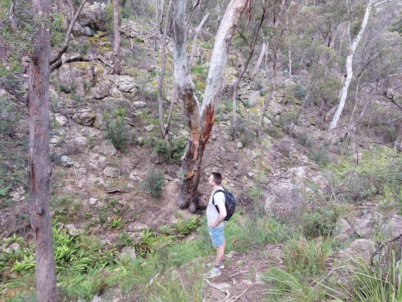
David looking confused and realising that we are lost.
Abrahams Bosom, Marions Way, Coomie's and Wreck Walk — Abraham’s Bosoms Reserve (Jervis Bay Area)
If you’re passing through Jervis Bay, this is a quick and easy loop that you can check out. This 5km up and down loop takes you through Abraham’s Bosom Beach, Shell Beach, Wilson’s Beach, Lobster Bay, then back to the car park.
It’s a lovely beach walk, and I would recommend that you bring your swimmers along. You may suddenly get a strong desire to swim, especially when the weather is warm. It’s a dog-friendly walk too.


South
We went on a few road trips down the coast from Sydney, so the following hikes are all coastal.


Sandy Creek Loop Track — Bournda National Park
On the way down to Merimbula and Eden, you will find the beautiful Bournda National Park. The Sandy Creek Loop is the best trail you can take, and it’s only 6km long. We completed this in 2 hours, stopping along the way to admire the surrounding nature.
Well-maintained, up and down trail with lots of colourful mushrooms. The track passes through a forest and a beach, looking at the picturesque Bournda Lagoon and Sandy Beach. It was lovely. If you have the time, pause to complete this trail.
Beowa National Park
There is a lot to explore here! You must make this national park a stop on your road trip itinerary for a few days.
If our way ever crosses this national park again, we’ll be doing the Light to Light multi-day hike. We explored parts of it during our trip, and it’s worth coming back.
You must also bring swimmers! David and I are not the types of people who would go to a beach on a summer weekend, nap on the sand, dip in the water, and have drinks. His fair skin is not happy with the sun (gets burned easily), and my ears are not happy with the ocean (they ache easily). However, we swam TWICE every single day while exploring this national park. It was December, and there were so many hidden, tucked-away, lonely, little, shallow beaches that were warm, inviting and crystal clear. Yes, we swam with fish in warm, still water. What a dream!
We also loved the unique colours and shapes of the rocks in this area.
Side note: this national park used to be called Ben Boyd National Park. We were a bit confused as half of the road signs were pointing at Ben Boyd National Park, and the others were pointing at Beowa National Park. They’re referring to the same place.
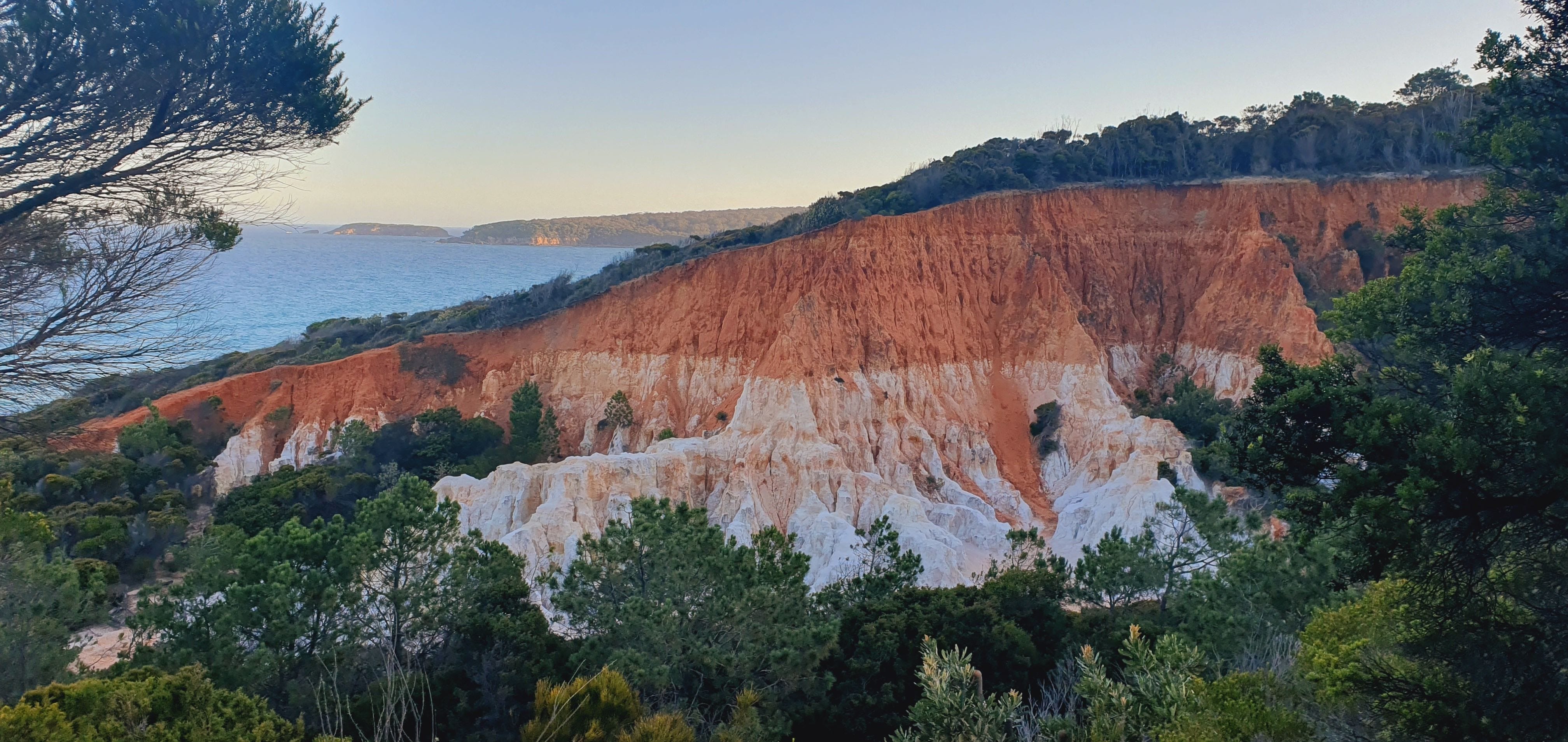
Pinnacles Loop Walking Track
This trail begins at Pinnacles Beach. It is literally a 1.1km loop (Grade 3), so it won’t take you more than 20 minutes. Highly recommend!
The trail takes you to 2 main lookouts to see a large hill (or a small mountain) with severe erosion, revealing two (or three, if your eyes are good) layers of colours on a sheer wall. Orange at the top (red gravel clay), cream in the middle, and white at the bottom, the Pinnacles is a natural artwork.
Pambula River Walking Track (Pambula Inlet via Jiguma Nature Area)
There are multiple trails that cross the Pambula River. We completed the 3.5km out-and-back trail to Jiguma Beach and Barmouth North Beach.
Bring your swimsuits for this hike. There are plenty of secluded spots for a peaceful swim (or float). The sun dances off the ripples of the clear water and sparkles. It is a gorgeous sight!
Haycock Point to Barmouth Beach Walking Track
6km out and back. This was a nice 2-hour coastal track. You can start this hike from either the Barmouth Beach carpark or Haycock Point picnic area.
We saw echidnas and large goannas in this area. I feel like there are two different types of goannas — the older, slow goanna with wise, thoughtful steps, and the manic, fast, younger goanna that runs up a tree as soon as they see a person.
Terrace Beach via North Head Track
6.6km out and back and 170m elevation. This took us 2 hours, and most of it was through a sandy forest. It was nice but not very exciting.
The ocean views at the end were lovely, but if you are short on time, this trail can be skipped.
Boyds Tower Walking Track
1km out and back, super easy walk on a platform, will lead you to the historical Boyd’s Tower and gorgeous scenery.
It’s coastal, sunny, windy, and a great location to watch whales. Highly recommend!
Hope this has inspired your next journey! There is a lot more to explore in NSW.
Note: the wildlife down south is not afraid of you. As the image on the bottom left shows, they are quite brave with their approach.
In the near future, expect our hiking posts to be about Victorian trails.
Questions: as always, if you have any questions about my notes, leave a comment and I’ll reply.
Thanks for reading! Subscribe for free to receive new posts and support my work