
Part 2: Exploring North of Royal National Park (NSW)

Check out Part 1: Exploring Royal National Park if you haven’t done so yet.
North-West
Getting back into a hiking routine in 2024 (after 2 months of rehab from my knee injury) involved a few weekends in Loftus, which is when I discovered the trails in this area. These trails are short and scenic, with flat terrain and gentle slopes, making them great for trail running, recovery/rehab hikes, and family day adventures. My ideal weekend would be to hike through 4 in one day, with a picnic break in the middle.
Kirawee Bushwalk
I found this hike on All Trails. It’s a 4km easy loop (takes 1-2 hours approximately) with a 90m elevation gain. https://www.alltrails.com/trail/australia/new-south-wales/kirrawee-bushwalk
The trail starts on Helena Street, next to Kirrawee Oval. We grabbed coffees from a local cafe beforehand. Start of this trail wasn’t very obvious; it looked like a generic sidewalk. After 5 minutes though, we found ourselves in a picturesque journey with wildflowers — pleasant surprise.
This is an easy route that crosses the Savilles Creek, diverges inland with a slight uphill, then circles back, following the river with a slight downhill. At the same time, the terrain is rocky with some tree roots, resembling a narrow fire trail.
I would carry your phone throughout this trail. The route wasn’t well-marked with some overgrown sections that we had to push through. We did not see anyone on the trail. However, we saw a shy echidna in the bush, which was the best part of our hike.
This was a nice and relaxing morning (I mean, I love being in nature).
Grays Point to Audley Loop
Another hike I found on All Trails. It’s a 5.6km easy loop (takes 1h 30 mins - 2h 30 mins approximately) with a 160m elevation gain. https://www.alltrails.com/trail/australia/new-south-wales/grays-point-to-audley-loop-via-hacking-river
The trail starts near the Grays Point Oval or the Grays Point Primary School. Fire trail like, rocky terrain. The route was quite flat in the first 500m, then had a 75m descent within the next 200m — perfect to test your knees after an injury (or train your joints if you want to wear weighted packs). However, I may not recommend it during heavy rain. The views were lovely, looking down to the Hacking River.
Once at the bottom of the slope, the terrain goes flat and follows the Hacking River for about a kilometre. We walked up to the Audley bridge, saw the kayakers and paddlers, the cockatoos, and the cafe on the other side of the river. Then, we began ascending on the Honeymoon Track (cute name).
This is a 105m climb (including some stairs) over approx. 1.5km to the Royal National Park Environmental Education Centre. Along this section, there are a few turns to side trails, so make sure you don’t diverge. Rest of the trail is flat.
Overall, this was a lovely picturesque hike and Audley is perfect for a picnic. Not sure why I did not come back to do this trail again.


Loftus Loop & Temptation Creek Loop
Two other loops I found on All Trails which intersect at the beginning. The big/outer loop on the map is the Loftus Loop which is 6km with an elevation gain of about 120m (doable in 1h 30 mins - 2h). The smaller loop (marked by the blue pen) is the Temptation Creek Loop which is 4.5km with an elevation gain of about 90m (doable in 1h 15 mins - 1h 45 mins). We completed both on the same day, as it was convenient for us.
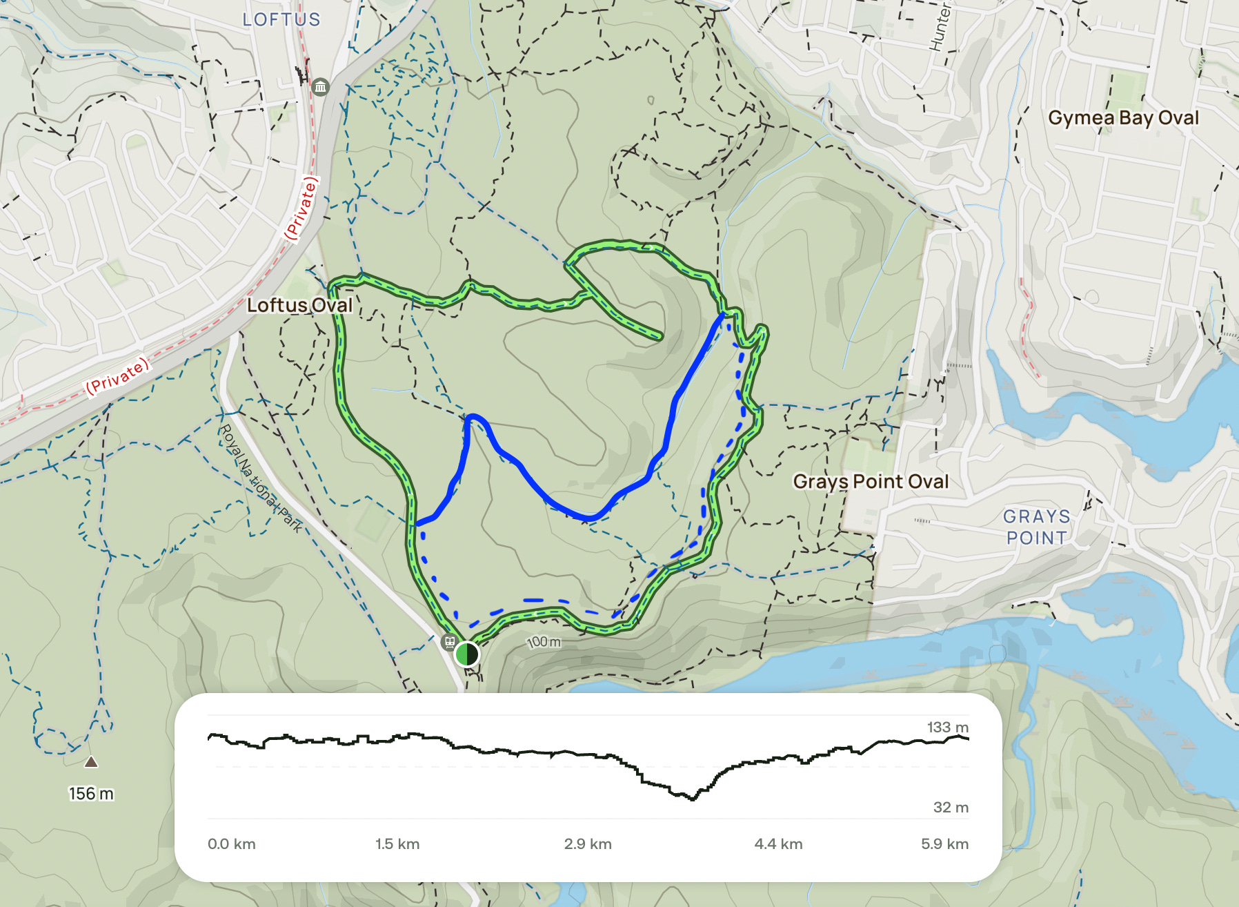
Both trails start from the NPWS office at 159 Farnell Avenue. There is a car park there (and toilets). Despite exploring at 10 am on a weekend, we only saw two other people on the trail; they were riding their bikes.
I would describe both trails as easy bush walks with flat terrains (probably suitable for trail running), a few rocky sections here and there. Pay attention during the trail because there are bike routes that diverge off from the main path. Temptation Creek loop resembles a fire trail which sees a cute small creek (might be a bigger creek during winter).
Overall, Loftus Loop was not a scenic route, but Temptation Creek made up for it with the Bungoona lookout facing the Hacking River (recommend checking out at sunrise or sunset).
North-East
If completing the Coastal Track is on your hiking bucket list, then exploring the trails at this end of the Royal National Park would be a good place for training.
Some warnings:
It will be windy, even in summer. Don’t wear loose items.
The sun will burn your face, even in winter (and even if you have Mediterranean skin, like me).
These trails may look flat and sandy, but they are not beach walks; I feel confused every time I see someone wandering with flip-flops.
Routes to the beaches get very crowded during summer with families, so parking becomes challenging.
Tips:
During the whale migration seasons, keep one eye out on the ocean. I spotted a few whales in the past.
The ferry ride from Cronulla to Bundeena is quite nice. Ferry times run past 5 pm too. So depending on where you live, driving may not always be the best option.
There is a cafe called Earth Thingz in Bundeena. I dreamt about their brownies but everything else I tried has been very delicious as well. Although…I only eat after a long hike, when I’m tired and very hungry, so…I may be biased.
If you have time, it’s possible to complete the first two hikes on this list in one day.
These routes are all great for trail running, especially during sunrise. It’s been on my wish list to come back for a long run.
Jibbon Head and Shelly Beach Loop
We discovered this route coincidentally while doing the Coastal Track. We were heading towards Bundeena and noticed that the trail split; the left turn was to the car park in Bundeena and the right turn was to Shelley Beach (on the Jibbon trail). Totally exhausted, we took the short cut out. Later on, we looked this trail up on All Trails and came back.
7.4km loop, 100m elevation total, expect to hike for about 2 hours. https://www.alltrails.com/trail/australia/new-south-wales/jibbon-head-and-shelly-beach-loop
If the name of the trail isn’t enough to give you the hint, prepare for a beachy walk (and a very busy one during good weather). If you are not time restricted and enjoy dipping in the beach, then don’t forget your swimmers (recommend Jibbon Beach).
On All Trails, the hike seems to start at the Bundeena ferry terminal. If you’re driving to Bundeena, you may want to officially start from the Loftus Street Reserve (Neil Street), or wherever the car park is.
This is a beautiful coastal walk with lovely beach views. It’s got a flat, sandy, dry and slightly rocky terrain. We have two different experiences on this trail; the first one with sore ankles (that sandy terrain was a nightmare), and the second one with strong ankles (super easy and fun).
The first landmark is Jibbon Beach (about 1.5km into the hike). There is a shortcut that connects this beach straight to Shelly Beach. However, this hike goes all around the coast, so if you stick to the trail, your next landmark will be Little Jibbon Beach. This is where you can see the rock carvings.
Shortly after is the Port Hacking Point. Yes, it’s beautiful for taking pictures, but also very windy. I felt like yelling out, “brace yourself, fellow hiker! Head down, lock in the arms, push forth!”
From that point, the trail begins to circle back, heading towards Shelley Beach. Narrow path with white sand and green bush around. There will be a split-off. As much as it’s tempting to head towards the coast with stunning ocean views, this trail heads further inland to complete the circuit.
There is a slight uphill (negligible) at this section, white sandy rocky ground again, and bush. If you’re lucky, there are seasonal pink flowers that bloom. Watch for your foot as small snakes are relatively common.
Eventually, you’ll come to the car park. There are toilets and water filling stations there. After a kilometre through the suburbia, you’ll complete the loop.
Overall, the rock formations you’ll pass on this trail are very cool. It’s like there were lots of bubbles of various sizes hidden inside the large rocks, and they exploded hundreds of thousands of years ago, leaving their fossils behind. There are lots of birds to spot. If you’re into bird photography, this is the spot to be.
Bundeena to Wedding Cake Rocks
The famous track to the Wedding Cake Rocks starts at the Royal National Park car park in Bundeena (where the information signs, toilets and water filling stations are).
5.6km out and back trail with an elevation gain of 180m, and an estimated time of 1h 45mins - 2h 15 mins (depending on how many photos you would like to take). https://www.alltrails.com/trail/australia/new-south-wales/bundeena-to-wedding-cake-lookout
Easy and popular route that’s slightly up and down on sandy, dry and rocky terrain. As mentioned under the review of the Jibbon Head and Shelly beach Loop, the white sand is lovely (unless you have sore ankles), rock formations are cool, and the ocean views are stunning.
However, most people arrive expecting to see the white-coloured limestone called the Wedding Cake Rocks. They envision themselves sitting on the unique cuboid geographical formation 25m above sea level, and snapping iconic pictures.
Instead, you will encounter an emergency rescuer statue (in the shape of a poster) with a quote, “I hope we never meet.” It’s basically a warning sign, revealing how many people fall off these rocks and get saved (most die). Public access to the top of the Wedding Cake Rocks was closed off in 2015 by tall fences, after a geotechnical assessment. To put it simply, this rock formation is estimated to collapse into the ocean. However, some people still climb over the fence for Instagram/TikTok shots, hence why the additional warning signs.
In my opinion, watching whales during sunrise/sunset and capturing them with a camera is much more exciting on this trail. Don’t trip over a rock but keep an eye out on the ocean.
Again, watch out for the snakes during the initial part of the trail. The second half of the trail gets a lot of wind, so don’t carry loose items with you.
Beautiful trail! Even more beautiful if you can avoid crowds.


Bundeena Drive to Marley Walk
This is another trail that we discovered while doing the Coastal Track. 8.5km out and back trail with an elevation gain of 180m, and an estimated time of 2h 15 mins - 3h 15 mins. https://www.alltrails.com/trail/australia/new-south-wales/marley-beach-via-bundeena-drive
You can pack in your swimmers for this hike (some people do), but be prepared to battle with the ocean waves. Marley Beach is rough and windy. I have actually seen surfers carrying their boards on this trail. Seemed like too much effort before you even got to the waves, but I can also see the attraction for it.
On the way to Bundeena (the Bundeena Drive), there is a small but obvious parking space with an obvious hiking trail turning right. That's where the hike starts. This is not a very popular trail (in comparison to the other coastal hikes in the national park), so parking shouldn't be an issue (unless you pick a weekend during the summer school holidays).
Marley Trail is on a mostly flat, dry and sandy terrain (similar to a fire trail), like most other walks in the Northern part of the national park. It is a constant downhill through the bush (with pretty wildflowers and birds) until the coastal views.
The first landmark of the trail is about 2km in — Marley Creek. Cute, picturesque and rocky. About half a kilometre later, you’ll see a trail split off. We took a left onto the Little Marley Fire Trail, as that’s the quickest way to the beaches.
A kilometre later, you’ll reach the second stream crossing. I felt the winds blowing in at this point and got happy and bouncy. To my prediction, soon we saw the ocean — the most exciting point of the trail.
The footpath here becomes a metal platform. If you take a right turn, you'll head towards Little Marley Beach. If you take a left turn, you'll head towards Marley Beach. Your choice. Both are lovely beaches at an equal distance away. What's special about the Marley Beach is the amount of sand there. That sounds weird. Quoting from my Coastal Track post…
“Marley Beach is big with tall white sand dunes, wild ocean waves, seagulls exploring and seaweed washed up. It looked like an isolated planet.”
Wide, dense beach hit by the powerful ocean waves — and just the two of us — very impressive. I felt small standing there.
Even though the first time I stepped on this beach was painful (and caused an Achilles injury), this is a lovely trail to come back to.


That’s all for now. Part 3 will focus more on the coastal trails which will help you train for the Coastal Track in Royal National Park.
Questions: if you have any questions about my notes, leave a comment and I’ll reply.
Thanks for reading! Subscribe for free to receive new posts and support my work.