
Exploring Ku-ring-gai Chase National Park, NSW

Ku-ring-gai has been our ‘go-to’ hiking training zone in our early days of hiking. We used it to get used to hiking, build up balance and mobility with backpacks, and recover from a knee injury.
Most of the national park is rocky and dry, with wildflowers that bloom during spring and small creeks that fill up after rain. Most of the terrain consists of small and crumbly rocks, which makes hiking tricky when it rains. During the summer, good sun protection is a must-have, as there isn’t a lot of shade.
Yes, you will find snakes, impressive cobwebs, large spiders (I mean it), leeches, butterflies, lots of little birds along some fire trails and some narrow forest paths. Some parts of the park are not well-maintained (or updated with accurate information online), as it does not get a lot of traffic.
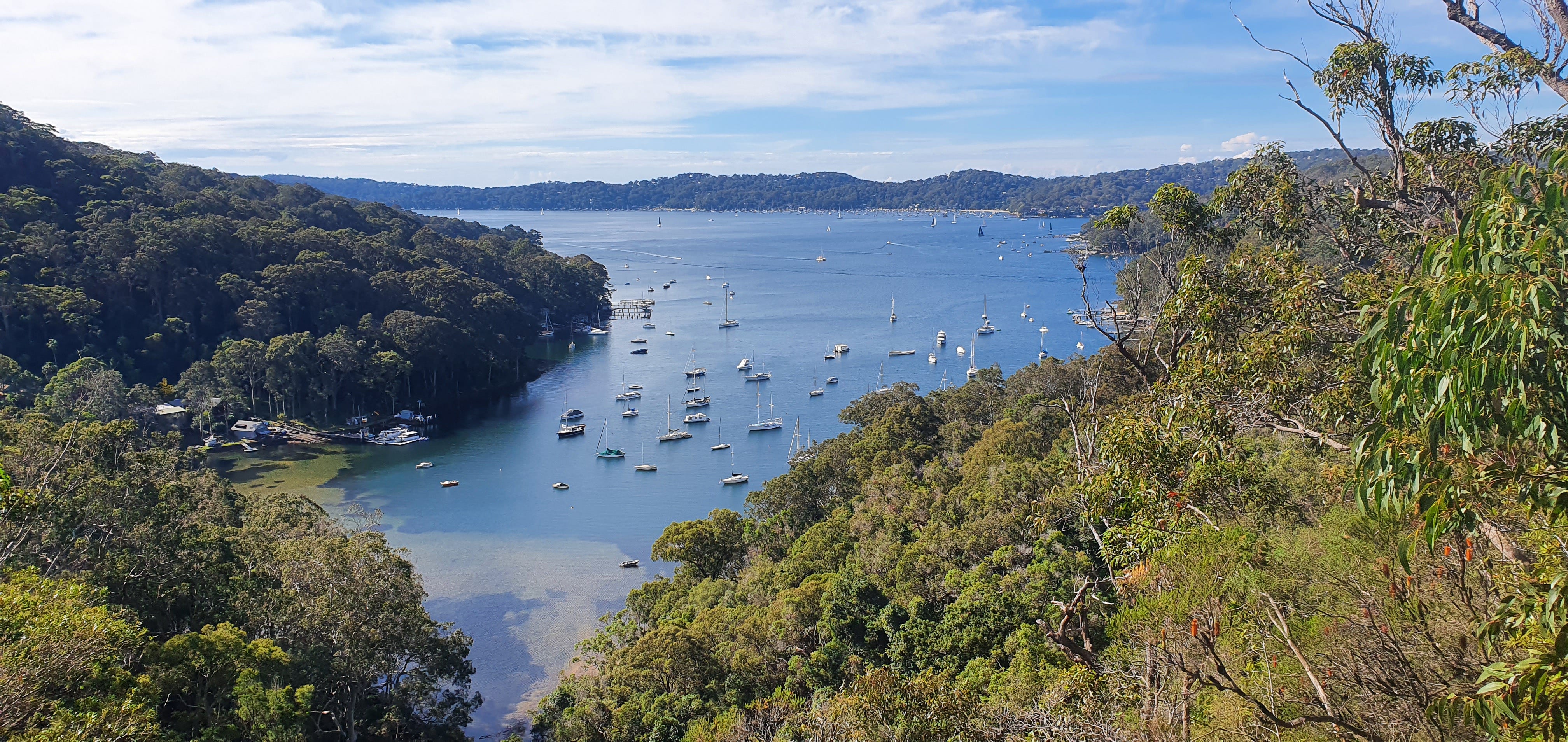
Views of this national park are absolutely stunning online, but most parts are inaccessible unless you are travelling via a water vehicle. If you would like to capture the best views, I would recommend exploring this area in various ways, like a mix of hiking, camping, kayaking, and catching a water taxi, and some of the nearby suburbs, like the coastal drive through Church Point, Newport, Avalon Beach, Whale Beach, and Palm Beach.
For that reason, while the waterfronts are very popular, the rest of the national park is very isolated from the crowds. We did not see a single person on most of our hiking training days (for about 4-5 months). You will come across the occasional cyclist couple.
While it is time-consuming, parts of this national park are also accessible by ferry departing from Palm Beach if you don’t have a vehicle.
Lovett’s Pools & Elvina Waterfalls
3.2km return, moderately challenging trail with some elevation to climb up to the natural pools. While the trail is known to the locals, it is not accessible by foot, which allows it to remain a private spot. You would need to take a water taxi to drop off at Lovett’s Bay. We were very lucky to discover this trail on one of our weekend getaways.
There are 2 parts to this trail.
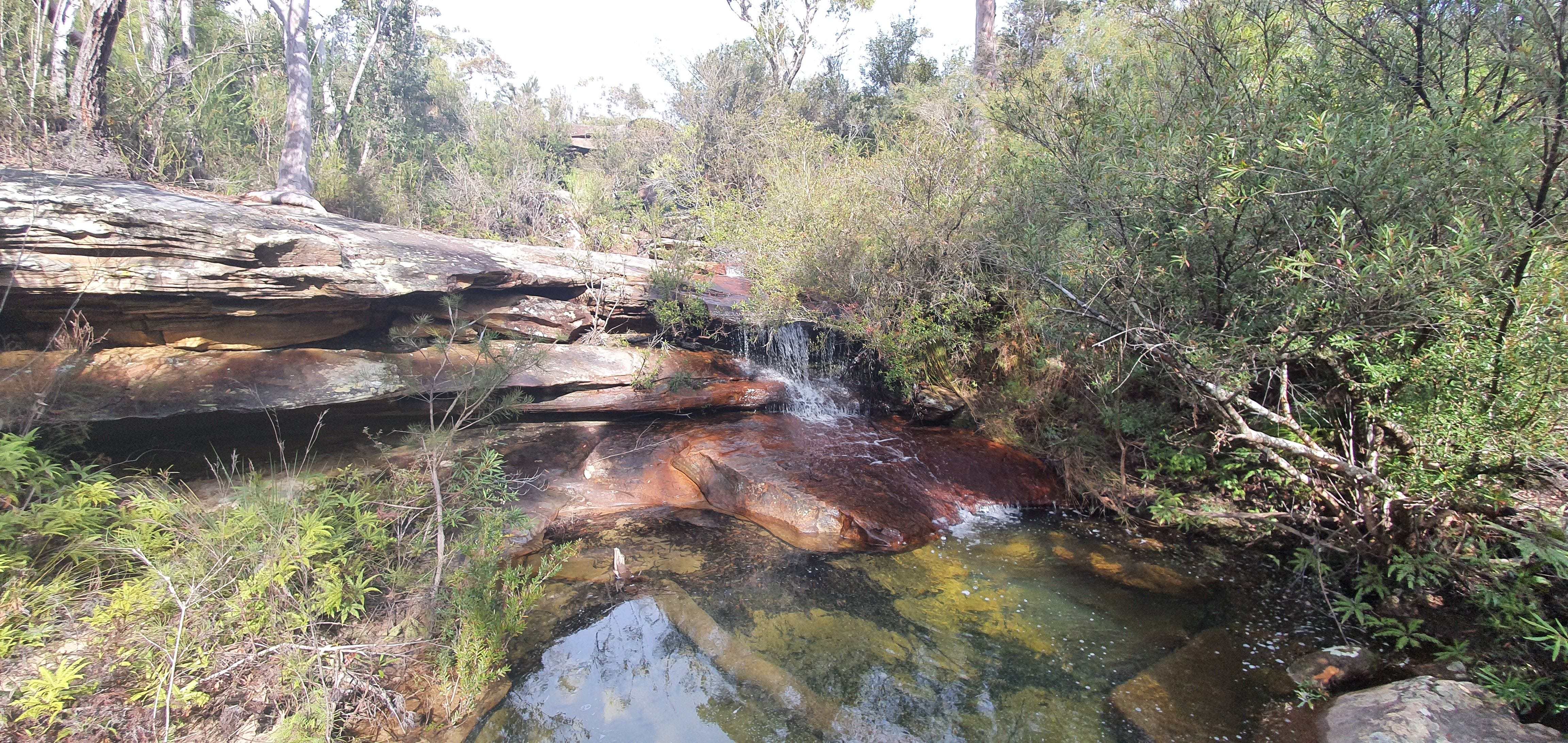
The Waterfall. From the drop-off point in Lovett’s Bay, take a right and walk 100m. You will reach a rocky section and wonder if you are lost. Keep travelling on the rocks and you will find the tall waterfall merging into the bay. Wonderful spot.
The Pools. From the drop-off point in Lovett’s Bay, we walked about 300m to the left and kept an eye out for a narrow bush trail on the right. We spent about 20 minutes trying to find the start of this trail. This trail is not marked, so it’s best to ask the locals. That’s what we ended up doing.
The trail climbed up winding and narrow through the bush. We saw a naughty bush turkey (who has stolen someone’s thong) on our way. Once you are at the top, there will be a rocky section with a shallow pool. Keen walking because there will be a deeper rock pool once you reach the end.
This is a spot one would want to paint. It is a spot one would want to play some music and have a romantic picnic. There was no one around. The water views were stunning. We loved it so much that we came back the day after.
The view I’m talking about.
The Basin Track and Mackerel Track
9.6km return, 340m total elevation, Grade 3 — we completed this hike in January 2023 and began from the Basin Campground. However, on the main road in the Ku-ring-gai Chase National Park, you can pull your vehicle to the side and park.
From the Basin Campground, there is a short but steep climb back up (about 140m elevation). It was a very hot day. Our journey was on a fire trail with some covered and some exposed parts. Coming from the campground, if you continue to the main road, you’ll see the Basin Aboriginal Rock Art Site.
Or you could take the first right, then you’ll head towards the Mackerel Beach Track. It’s a 120m descent, then that much to climb back up. Some people say it’s worth it due to the views at the end. Honestly, the beach was closed (with warning signs) when we did the trail, so we retraced our steps, disappointed. The views were nice, but nothing special. A few months later, we found out that access via foot had been permanently closed.
Tired and disappointed
If you are hiking from the road, stopping at the Basin Campground for a picnic (and a short swim) is highly recommended.
More info here — https://www.nationalparks.nsw.gov.au/things-to-do/walking-tracks/the-basin-track-and-mackerel-track
Bairne Walking Track
9.7km return, 258m total elevation, Grade 3 — I have mixed feelings and complicated (action-packed) memories about this track, but I am aware that the trail has been much better maintained since 2023. We completed 2 versions of this trail — one in early December 2022 and the other in January 2023 (which was a bit of a survivor story).
The first time we attempted the trail, we were well-behaved and stuck exactly to the route on the map. Most of the journey was on a very exposed and dry fire trail. I don’t know why we were there during December, as it was extremely hot.
We parked on the side of the road. It’s pretty safe to leave your vehicle for a couple of hours. No one was around for the entire journey. But we came across some large spiders, a snake and bush turkeys. The trail had a slight climb up and down the whole time, but nothing exhausting.
The final points were nice — worth taking pictures.
The second time we attempted this trail, I made the mistake of assuming I knew the area (so we could go off exploring). We didn’t just make up a route to follow. On the map, there was a fire trail that led down to Portuguese Beach. I checked on Google Maps — the beach looked stunning. So I was confident.
This trail splits out to other small fire trails, two of which are noted on maps. That was an experience from an adventure movie — I need nothing more to say. It was like we were explorers in the 1700s, discovering new lands via a forest.
The standard Aussie bush turned into trees. The wide, dry, crumbly rocks turned into a very narrow, sandy forest. We were stepping over roots, ducking down, swinging our sticks around to not get caught in a giant cob web, and brushing off the sweat. Not a maintained trail at all. But, if you take a good camera with you, it’s possible to see disturbingly large spiders, some of which have colourful backs.
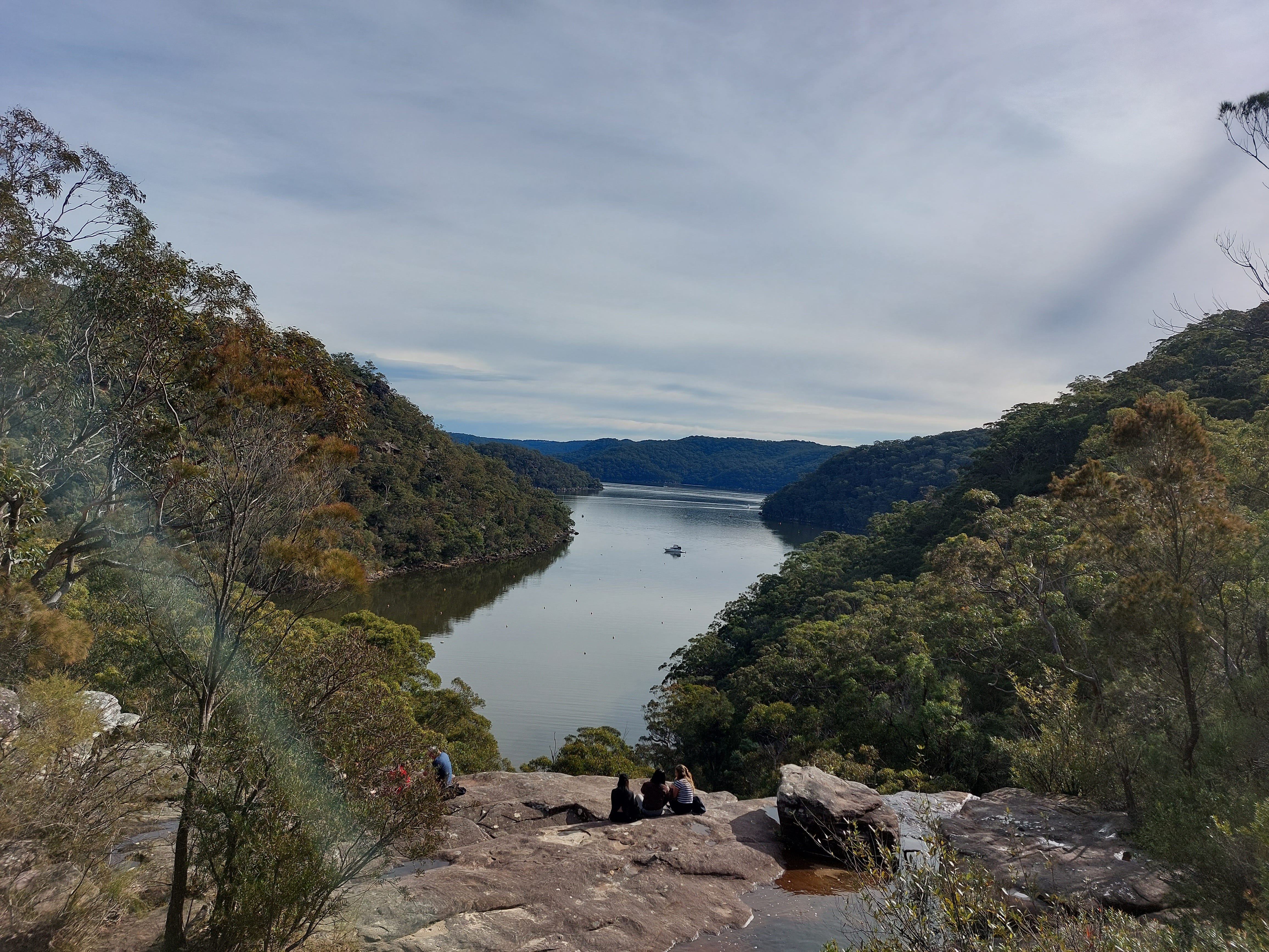
Not to mention, there is actually no foot access to the Portuguese Beach. Apparently, one had to kayak their way there. Lesson learned. My mistake. The trail ends on a cliff edge with views covered by skinny trees.
I remember that point very clearly because we finally found a rock to sit on and drink our water. But it was a rock with leeches, and after 5 minutes, I bounced up screaming, “leech, take it off, leech!” It was the first time I ever had a leech attach itself to me. Cute. I think that number is 7 now, so I’m much more used to this experience (and don’t bounce around screaming).
That day, we had to return to the Basin Campsite and catch the ferry to Palm Beach, where our Jeep was. We lost so much time bush bashing and drained our energy that we were worried about missing the ferry. I am unsure if this was an intelligent idea, but we decided not to trace our steps back. Instead, we decided to take the other side trail on the map that went to the Bonnie Doon Wharf. I think we were much more certain of this trail because it had a wharf at the endpoint. We also hoped to catch the ferry from there.
We hiked out of the 1km mess and began our 1.5km walk. Much better trail conditions, even though the route was still narrow. The last 500m were very exciting, as we could see the water. Despite the fact that this trail was also unmaintained, the views made up for it. Clear, sparkling waters with touches of turquoise filled my heart.
We did not get on the ferry from the Bonnie Doon Wharf. Apparently, the ferry comes once every 2 hours, and swimming across to the Basin Campsite would take a shorter time. I am not joking. That’s what we did.
The water was not too deep, manageable for walking if you are over 165cm. Calm, no waves, no tides, and warm water were wonderful after a tiring day. Be careful walking across; there are a few sharp rocks at the bottom (mostly safe though). I was a little unfortunate, as towards the end, I stepped down without looking and cut my foot.
There are showers at the Basin Campground. We washed off, dried ourselves with towels, and jumped on the ferry back to the Palm Beach.


Here is some more information about the trail (you’ll be able to see the side trails I mentioned on the map too) — https://www.alltrails.com/trail/australia/new-south-wales/towlers-lookout-via-bairne-track-and-soldiers-point-trail
Salvation Loop
4km circuit, Grade 3 — easy and nice walk. It should take you a little bit over an hour. The trail is very exposed, like a fire trail with some bush around. The journey will get very hot during summer, and you may encounter snakes. I thought it was suitable for a trail run, if that’s what you are into.
If you have more time to explore, combine this with the Wallaroo walking track.
More info here — https://www.nationalparks.nsw.gov.au/things-to-do/walking-tracks/salvation-loop-trail
Wallaroo Walking Track
9km return, Grade 4 — fun walk with a nice view at the end. Most fire trails are quite boring, so ending it with water views is something that I’ll always appreciate.
This is an up-and-down rocky trail with a steep slope down towards Cowan Point. It is less exposed with some trees around. We have seen people on this trail in the past (must be due to the views).
I recommend bringing some snacks and having a short picnic at the end. You will reach a rocky overhang with lovely water views. Quite romantic!
More info here — https://www.nationalparks.nsw.gov.au/things-to-do/walking-tracks/wallaroo-walking-track
Topham Walking Track
3.7km return, Grade 4 — another fun walk, a shorter alternative to the Wallaroo Track, with nice views looking to Cowan Water at the end.
The trail has some narrow, windy sections with sandy terrain and some fire trail sections with rocky terrain. It is possible to come across snakes during the summer.
More info here — https://www.nationalparks.nsw.gov.au/things-to-do/walking-tracks/topham-walking-track
Other Things To Do In The Area
As mentioned before, for the best experience and views of the national park, I recommend exploring in various ways and checking out the nearby suburbs.
Camping: The Basin Campground is the only place you can camp in Ku-ring-gai Chase National Park. This waterfront campground is totally worth spending a night (or more) in. Book via NSW National Parks website - https://www.nationalparks.nsw.gov.au/camping-and-accommodation/campgrounds/the-basin-campground
The beach is sheltered (no waves) — perfect for swimming, kayaking and paddling. Fishing is allowed; we watched some families catch their dinner for the night. The facilities are great. There are picnic tables, barbecue areas, drinking water, showers, toilets, and even a small coffee vending machine (that was impressive). It’s a large grass area with +100 camping spots. Yes, it’s busy and very popular (so book in advance). Yes, it’s full of families.
While it is not accessible by car, you can drive to Palm Beach, park your car and catch the ferry. The ferry service was good. It’s easy to carry anything across. We saw families carrying over beers, bikes, balls, and fresh groceries to cook.
Expect to see lots of kookaburras, wallabies, echidnas and tall lizards (about 1.5m). The friendly lizards and wallabies will happily take your food, so don’t leave anything unattended outside.
Exploring around is not the easiest, as there is a steep climb you need to hike over first to get to the main road. Then you’ll need to find fire trails to explore.
AirBnBs: if you prefer a luxury trip, I will highly recommend the AirBnBs along the Scotland Island, Lovett Bay, Elvina Bay, Morning Bay, and Night Bay. Bring swimmers along too. These are inaccessible by car, but most AirBnB hosts will help you organise a water taxi (for some, this is included in the cost). It is quite a special experience to ride a water ferry to a secluded cabin along the water with lots of greenery, a 10-minute walk from the waterfall. It could be a perfect couple’s getaway.
Scotland Island: ferries depart from Church Point. Beautiful place to explore and walk through greenery. Kayaking and paddling are other popular activities.
Swimming: Palm Beach and Whale Beach have a few nice spots to swim. Surprisingly, they were not busy during the few times we visited.
Dining:
Pasadena at Church Point: great views and entrees. We had zucchini flowers, some octopus and arancini, and I still remember it.
Barrenjoey House: everything was delicious (we had the barramundi), including the sides, but I had the best pavlova of my life there. We also ordered an unforgettable merengue ice cream sandwich. The desserts were unique and creative versions of traditional sweets — and they pulled it off so well.


Questions: as always, if you have any questions about my notes, leave a comment and I’ll reply.
Thanks for reading! Subscribe for free to receive new posts and support my work.