
Bluff Mountain Walking Track, Warrumbungle National Park (NSW) — Walker’s Notes

October 2022. We went on a road trip for my birthday to watch the stars at a “dark sky zone” and hike. We were new to hiking then. About 6-7 months before the trip, we committed to hiking training and bought our heavy gear boots, day packs and put together a small first aid kit.
What is a “dark sky zone”?
Dark sky zones are spaces around the world with exceptional starry nights and a nocturnal environment. These parks are certified and protected for their scientific, natural, and cultural heritage. A lot of the conservation work is about controlling artificial lighting, so we can continue to admire the magical night sky with our naked eyes.
Fun fact: the Warrumbungle National Park is Australia’s first and only “dark sky park.”
Highly recommend camping under a sky of diamonds, or booking a stargazing tour in Coonabarabran. We were very lucky to be able to spot Venus, Mars, Jupiter and Uranus with a telescope. The trick to seeing the night sky with clarity is turning off all devices. It’s also a trick to get a good night’s sleep, which we had plenty of in this national park.
Check out this nonprofit org for more info — https://darksky.org/
Where is Warrumbungle National Park?
“It’s in the middle of nowhere!” When I suggested going on this road trip, that was David’s response. Warrumbungle National Park (near Coonabarabran) is in central western NSW, a 6-hour drive from Sydney. We spent half an hour trying to pronounce the nearby town, Coonabarabran, and the name of the national park. David gave up.
The area is remote with not a lot of facilities around. The town has a Woolworths for groceries. Apart from that, there was an old petrol station (which closed quite early), a small pie shop opened in the morning (and they made bad coffee), and a small fried chicken shop (which seemed to be open on random days).
Camping is probably your best option. October to April (inclusive) gets quite hot! Nighttime temperatures drop a lot, though, so come prepared. Water is scarce in the national park. If you are camping, be careful with using your phones or other artificial lights after sunset.
Bluff Mountain Walking Track, General Info:
Length: 17km loop.
Duration: 1 day (7-9 hours, depending on your fitness level).
Note: there are camp sites on the way, and this trail intersects with a few lovely side trails, so I would recommend bringing your tent and taking 2-3 days exploring the national park.
Grade: 4 (but at the time, it felt like Grade 5 to us).
Terrain: rocky and some stairs during the first half of the trail. Grassy (bit of forest walk) and fire trail during the second half of the trail.
Skills Required: steep climbing (maybe a bit of scrambling). Technical hike that requires balance, mobility and good fitness.
Animals on Trail: butterflies, snakes and mountain goats.
Highly recommend: you bring PLD (personal locator device/emergency beacon), +2L water per person, and additional food in case of an emergency.
Popularity: popular trail for people of all ages (but not crowded, as everyone moves quite quickly).
Links: https://www.nationalparks.nsw.gov.au/things-to-do/walking-tracks/bluff-mountain-walking-track
Walker’s Notes
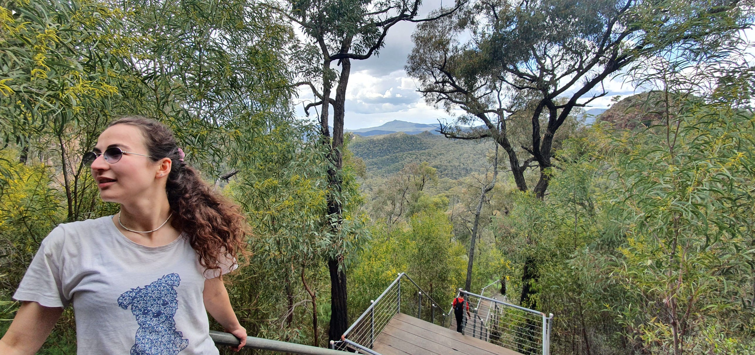
Warrumbungle National Park is gorgeous with giant, impressive mountains. No wonder it is a popular spot for hikers. It’s not just challenging, but also a very picturesque location to hike through. Pity that we were traumatised that day. Here comes the story.
We were originally prepared to do the Goulds Circuit walking track, which is an 8km loop. We began our hike from the Pincham Car Park. The trail is very well marked and maintained, and it is very popular, so you won’t get lost by entering the side trails.
It’s a constant climb (but not steep), and the terrain is very rocky. Close to the 1km mark, the trail intersects with another trail and starts to follow the Spirey Creek.
At 1.5km, the track splits to form a loop. That’s where we saw our first ‘track closure’ sign. We were a bit confused and didn’t understand whether it impacted our route or not. So we kept following the route. A kilometre later, we saw the signs again.
“Macha Tor closed.” It was so disappointing! I wanted to climb and see the Macha Tor. We were about a third of the way in, were not willing to retrace our steps back, and saw another sign that said, ‘Bluff Mountain walking track.’ It seemed to be a bigger version (loop) of our original plan.
HIM: Do we have enough water to go on for 2 more hours?
ME: Yeah. You reckon we could do 17km?
HIM: Yeah. I mean, we planned to do 8 already. We’re fast. We cover 4km an hour, give or take. Let’s have an adventure.
Note: to date, our longest ever hike was a Grade 3, 12km hike. David is the conservative one in this relationship, who usually prioritises safety and hardly ever has an excited, optimistic attitude towards changing our route on the day of the hike (especially when it comes to increasing our hiking duration or toughness). I was surprised to hear that from him. But I’m always up for a challenge, so I was not going to challenge back.
You guessed it right. This young and inexperienced couple had an adventure. It was an unforgettable day. Clearly, we made it out. But if you’re early in your hiking journey, don’t do what we did.
About 500m after the split off, we saw the Spirey View Lookout and continued with a steeper climb towards the Breadknife Gap. There were a few stairs on the way, which was a good idea, as the rocks are in uneven shapes with some erosion here and there.
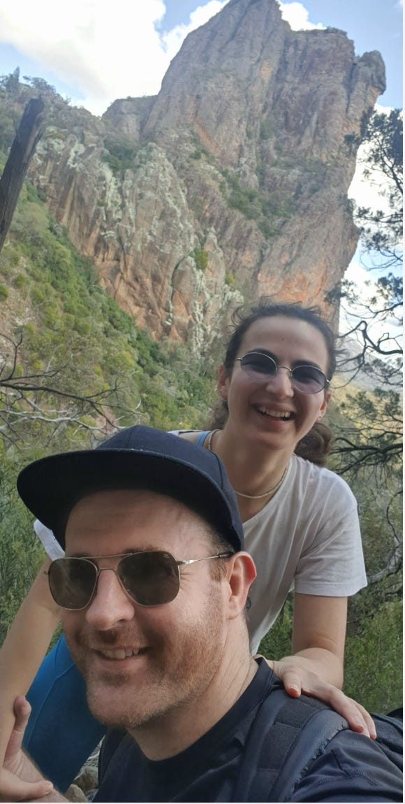
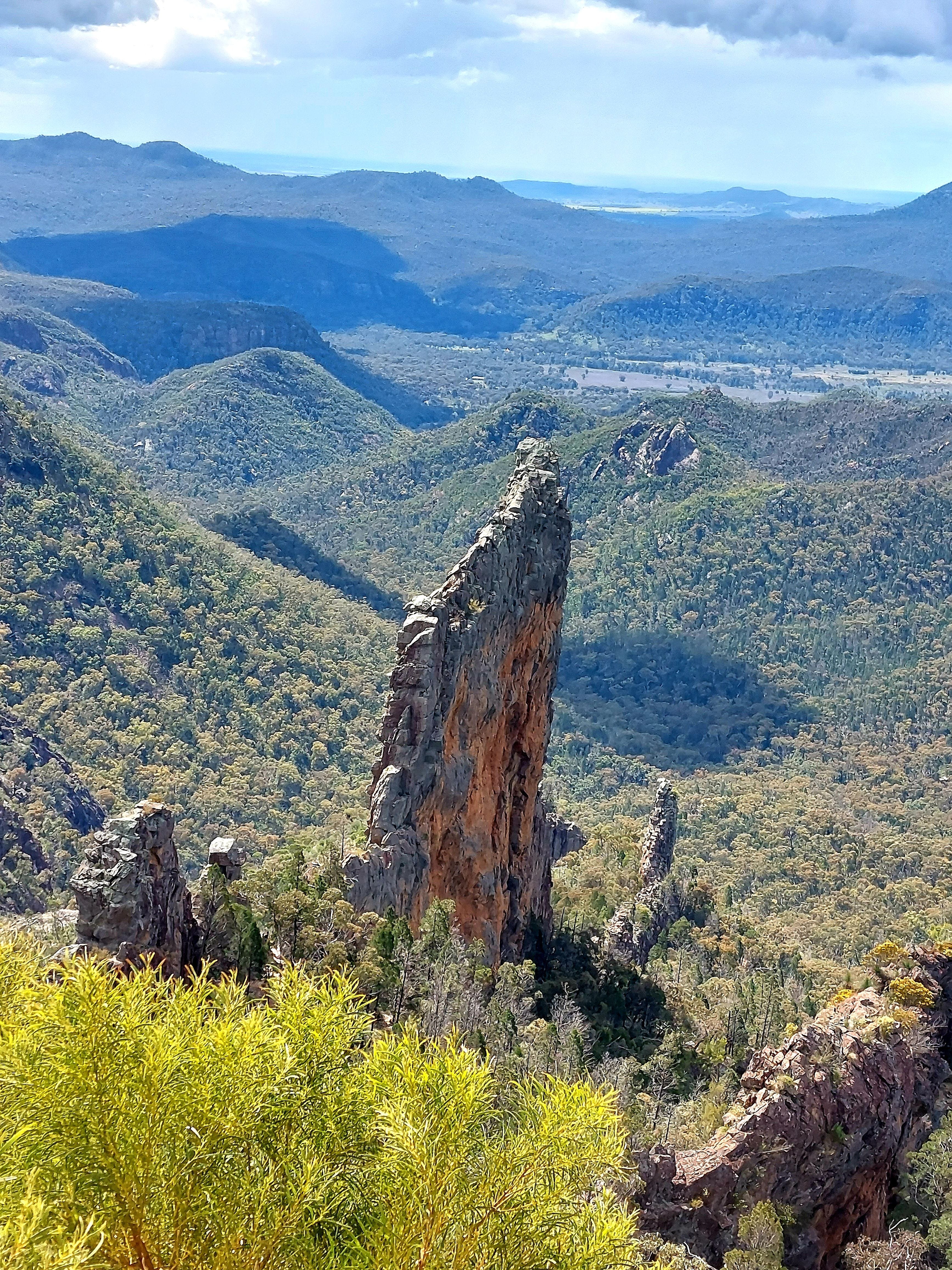
This is a photographer’s dream. Breadknife Gap is literally a skinny gap between two thin and sharp rocks that reach to the sunlight. We couldn’t take pictures, as there was a line of hikers trying to get through. We climbed on stone stairs, through the crack between the rocks. Looking around reminded me of the Avatar world without the fluorescent colours (because it’s Australia and the countryside is very dry).
All around you, tall, steep rocks point up to the sky, merge into sunlight. Random blobs of bush stick out from the crinkly surfaces of the rocks. It’s dry and mysterious. Some parts of the trail make you climb, and others duck down (if you’re tall) — it’s adventurous. We could see the ‘wow’ expressions on the faces of other hikers.
The first peak is on Lugh’s Throne.
ME: What’s up with these cool names? I feel like we’re in an Indiana Jones movie.
HIM: I know, right? The landscape fits the scene, too.
It’s a small peak in comparison to the rest of the peaks on the trail. 950m elevation at the 5km mark, we were feeling strong and confident. At that point, you can spin your head back and see the Fish Knife, which is another pointy rock. Nobody on the trail was fancy enough to know what a fish knife looked like — it was hilarious to be a part of that conversation. But somehow, we all felt like that pointy rock resembled a fish knife. It just had that sort of look to it. It’s hard to describe.


There is a small descent along a trail that twists and curves, then your second climb will begin. This one is a steep ascent to a much taller peak. There were a few bits which required some scrambling (or huge lunges, depending on your height). The 1.8km route draws a few zigzags. 300m elevation at Freeguards Prospect will give you incredible views. This was the highlight of the trail.
There was a big, amazed smile on my face as I stood on the highest point. Clouds slid past in peace. There was a slight breeze in the air. The sun hit our skin and warmed us to a comfortable temperature. Were are so elevated that it felt like we were one with the mountain tops, floating with the clouds.
This is a perfect spot for lunch and snacks. We stopped there for a little bit, had some food and water, and took some pictures.
This peak was our 8km mark. This was also the point when we realised how difficult the trail was. Unfortunately, it was too late. We had 9km ahead to complete the circuit. Or we had 8km back to the Jeep, but the way back was dodgy (too steep to come down). The hikers coming from the other side reassured us that if we go ahead, the trail gets much easier. So we decided to go ahead.
The rest of the trail was on an easy descent. That was the good news. The bad news was that our water and food were already running out. The weather was hot and getting increasingly hotter.
10km mark — you’ll see a few back-to-back lookouts. Dow’s Lookout, Middle Spirey View, and Kurrajong Corner. The trail will then do a zigzag again, and the terrain will get grassy.
11.5km mark — you’ll see a grassy, small campground. If we had our tents with us, this would have been a great place to end the day. There is a trail split off here, but we didn’t know where it would take us, so we stuck to the route.
The rest of the way is a bit foresty with grass and soil as the main terrain. We passed two large rock formations on either side of us on the way to the next campground. We also passed a side trail that went to the Cathedral Arch. It was highly recommended by a passing hiker. But no way we were going to extend our journey any longer.
13km mark — Danu Campground. It’s another small grassy campsite. I wouldn’t recommend staying here. We took a break here, had one remaining lolly and the two last sips from our water bottles. I’m sure that I was emotionally broken by that point. I felt that the most I could possibly do under that hot sun was 2 more kilometres, not 4.
Then, we heard grumbling sounds from the ground. It got louder and turned into gallops banging on and bouncing off the ground. I looked up and suddenly took a few quick steps back in shock.
Wild mountain goats. Maybe 12 of them, galloping down, fierce and free, their thick, long coats brushing along the bush, riding a wave of wind. My heart paused for a second, as I realised that I could have gotten run over by a herd of mountain goats. Then I watch them move so elegantly down a steep hill (almost a cliff), and disappear behind the trees. I was amazed. It touched my heart.
ME: David, I think there is a mountain goat in my spirit.
HIM: Babe, you're struggling to finish this trail. Not sure if there is a mountain goat in your spirit.
ME: There is! I feel it. I want to gallop out of this trail like them.
David let out a heavy sigh. Lack of food = lack of patience and humour.
There is a side trail from the Danu Campground to climb to Mount Exmouth. We were also recommended to explore this side trail by a passing hiker. Noted for a future trip.
15km mark — Burbie Campground. The trail along here was honestly easy. It’s a flat, long walk with not many notable landmarks. Or perhaps I was so tired (dragging my legs behind) that I didn’t look around to notice anything. This stretch was painful. We slowed down a lot.
Moving ahead, the trail follows the Crooked Creek and the Burbie Creek. It is a bit wet and muddy as a fire trail. If we were there during winter, this part of the trail would leave your shoes soggy. We slowed down even further at this stretch, but kept hopeful to be almost at the finish line.
17km mark — Camp Wambelong. Not a single campsite here has water. This was the point when we realised that the trail ends here, but our Jeep was parked at the Pincham Car Park. So it is actually not a full loop! Can you imagine the anger and disappointment flushing through my body in that moment?
I was going faint. I had my first cry of the day. I’m surprised I lasted that long before a cry. So we waited for 10 minutes. The sun began to go down. We had no choice but to keep pushing forward.
2km of walking along the main road to reach the Jeep. I remember how curvy the road was. Utes were flying past, bringing waves of wind with them, causing me to sway and tremble each time. We saw a dead snake by the side of the road. We were cooked under that sun, shining in sweat. David was checking the printed map every 5 minutes.
HIM: One foot in front of the other. Come on, baby. It should be just around the corner now. I — I know, I said that before, but I think we’re close now.
Somewhere along this route, I tried to have a second cry but distinctly remember my body being too shocked to actually cry. My face was almost frozen to put out an emotion.
I don’t know why we didn’t hitchhike. Probably because the road was very curvy and the Utes were going too fast to pull over. David suggested imagining dinner, so we keep our minds occupied. However, we were 1 hour’s drive away from any food options. So I could only imagine what was already in the Jeep.
White bread, banana, peanut butter, snakes (lollies).
Random items that don’t go together. In David’s opinion, a banana sandwich is the best snack. I wasn’t born in Australia, so the concept of sandwiching bananas — carb-ing carbs — is very weird. It’s thick and heavy, strange for me to imagine. David used to say, “you just got to try it once, and then you will love the idea.” And I would shake my head.
15 minutes away from the Jeep, I intensely imagined a smooth and creamy peanut butter, smashed banana, and stretchy snakes sandwich, licking my lips. It felt like this was going to be the best meal of my life.
Technically, our hike turned out to be 19km for the day with each person having 1L of water, 3 lollies and 1 thick oat bar. Total 500 calories (breakfast was a handful of blueberries and 2 WeetBix, 8 for David). We were on the trail for 8.5 hours that day. When we reached the Jeep, I didn’t know if I should sleep or eat.
Since that day, our traditional ‘tough trail treat’ became a peanut butter, overly ripe banana, and snakes sandwich. It’s a symbol of survival — a special part of our hiking culture.
Hope I didn’t scare anyone off from attempting this trail. We were inexperienced hikers back then and made a dumb decision to push beyond our capabilities and resources, which we never repeated again.
Otherwise, this was an awesome hike. A lot of the hikers we met on the trail also concluded that this is the best hike they’ve done in NSW. I would really like to drive back to Coonabarabran and explore the whole area with tents on our backs.
Questions: as always, if you have any questions about my notes, leave a comment and I’ll reply.
Thanks for reading! Subscribe for free to receive new posts and support my work.